[ Race Description ] | [ Race Application ] | [ WMAC Home ]
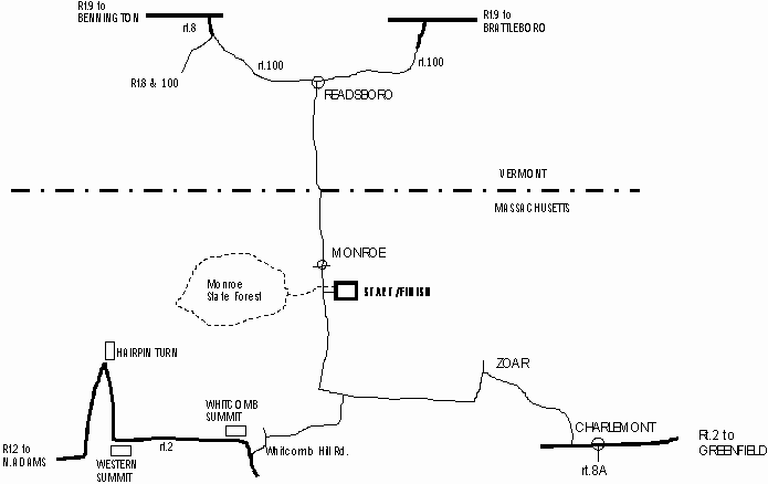
Directions:
Monroe, MA is located in the northwest corner of the state. There will be
signs at intersections from Rt 2 (MA) and from Rt 100 (VT) showing the way to the race.
From NORTH ADAMS, MA: take Rt 2 East to the top of the mountain. Just past
the Whitcomb Summit (approx. 4mi. past Hairpin Turn, 3mi. past Western Summit),
turn left onto Whitcomb Hill Rd. and bear right at the fork a couple hundred
yards later, continue (STEEP DOWNHILL) to the tee at the bottom (2.5 miles).
Turn left and follow the road along the river (across the train tracks and past
the Bear Swamp Dam) for 5 miles. The Dunbar Brook Picnic Area is down on the right.
From GREENFIELD, MA: take Rt 2 West to Charlemont. A few miles west of town
(past Rt 8a and past Zoar Outdoor Rafting) there will be an intersection for Rowe and
Zoar (just before the large bridge over the river). Turn right here. Follow this road
for 2.5 miles to a tee. Turn left at the tee and thru the small tunnel. Continue on this
road (following the river) for 8 miles. The Dunbar Brook Picnic Area is down on the right.
From BENNINGTON, VT: take Rt 9 East to Rt 8 south to Rt 100 north to Readsboro.
In the center of town at the wide intersection (before crossing the large bridge) turn right
onto Tunnel St. (which becomes River Rd.). Follow the road along the river for 8 miles.
After passing thru Monroe, the Dunbar Brook Picnic Area is down on the left.
From BRATTLEBORO, VT: take Rt 9 West to Rt 100 south to Readsboro. After the steep,
narrow downhill and crossing the bridge into Readsboro, turn left at the wide intersection
onto Tunnel St. (which becomes River Rd.). Follow this road along the river for 8 miles.
After passing thru Monroe, the Dunbar Brook Picnic Area is on the left.